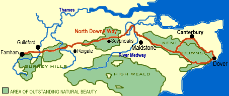
Farnham to Dover
This popular path follows the crest of the North Downs ridge across Kent, with wonderful views of the Surrey Hills. Part of the route follows the old Pilgrim's Way, trodden for hundreds of years by travellers from Winchester to the shrine of St Thomas a Becket at Canterbury. If you really want to enhance your appreciation of the countryside and history of the region, why not brush up on Chaucer's Canterbury Tales? His pilgrims followed this same route some 600 years ago.
The path begins in the chalk hills of the Surrey Hills AONB (Area of Outstanding Natural Beauty). The hills are topped by beech trees and open chalk grasslands. The Kent Downs AONB provides superb views over the open countryside split by sunken lanes and dotted with small villages.
The main path goes through Folkestone before ending near the famous White Cliffs at Dover, but there is an alternative loop through Canterbury. Sections of the path are open to horses and cyclists.
Although walking the entire path could easily take 10-12 days, the area is well served by public transport, and can be taken a bit at a time.
Highlights
Merstham - the remains of the first public railway in Britain (1805)
Farnham Castle - Bishop Henry of Blois' 12th-century keep
Waverley Abbey - the first Cistercian Abbey established in England (1128)
Leeds Castle - fairy tale castle set in a lake.
Godinton House and Gardens - a lovely brick manor house dating to the 14th century
Charing Archbishop's Palace - a medieval palace for the Archbishops of Canterbury
Dover Castle - magnificent fortress once dubbed 'the key to the kingdom'
St. Martin's church, Canterbury - the oldest UK church in continuous use (founded c. 560 AD).
St Augustine's Abbey - founded by Augustine in AD 598
Canterbury Cathedral - the destination for Chaucer's medieval pilgrims
Youth Hostels:
Tanners Hatch, Holmbury St Mary, Kemsing, Rochester, Canterbury, Dover
Maps
Ordnance Survey maps covering the North Downs Way:
Explorer OS maps (Scale: 4cm = 1 km / 1: 25000) - best for walking
EX137 Ashford
EX138 Dover
EX145 Guildford & Farnham
EX146 Dorking
EX147 Sevenoaks & Tonbridge
EX148 Maidstone & Medway Towns
EX149 Sittingbourne & Faversham
EX150 Canterbury
Landranger OS maps (Scale: 2cm = 1km / 1: 50000)
LR177 EAST LONDON
LR178 THAMES ESTUARY, ROCHESTER & SOUTHEND ON SEA
LR179 CANTERBURY & E.KENT, DOVER & MARGATE
LR186 ALDERSHOT/GUILDFORD
LR187 DORKING REIGATE & CRAWLEY
LR188 MAIDSTONE & THE WEALD
LR189 ASHFORD & ROMNEY MARSH
All OS maps are available at 10% off the retail price, by special arrangement if you order through Britain Express. Both laminated and plain paper maps are available.
Contact
North Downs Way Officer
Environment and Economy
2nd Floor Invicta House
Maidstone, Kent
ME14 1XX
Website: http://www.nationaltrail.co.uk/Northdowns