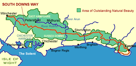
Eastbourne to Winchester
The South Downs Way National Trail is open to walkers, cyclists, horse riders, and adventurous disabled people using a suitable cross country buggy. It runs for about 100 miles between Winchester and Eastbourne following the rolling chalk downs of Sussex and Hampshire. The route follows prehistoric droveways that have been in use for at least 6,000 years, and numerous Bronze Age round barrows decorate the trail. Comparative newcomers are the Iron Age hill forts such as Devil's Dyke and Old Winchester Hill.
The western part of the Trail runs through rolling Hampshire countryside, including the attractive Meon valley and the National Nature Reserve at Old Winchester Hill. The West Sussex Downs are more wooded, but with some wonderful open areas.
As the views of the Isle of Wight fade to the west the Downs get progressively more open, and the last stretch in East Sussex is classic downland with big skies and views across the Weald to Ashdown Forest far to the north. Near Eastbourne the Trail splits; the bridleway route goes inland above the Long Man of Wilmington hill figure, while the footpath route goes along the spectacular cliffs of Seven Sisters and Beachy Head.
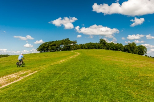
There are some fine wildlife sites along the route – chalk grassland is full of flowers in spring and summer, and butterflies are also very common. Chalk grassland depends on grazing for survival, and Trail users will meet sheep and cattle munching away all along the route. The Trail mostly runs along the crest of the Downs, but there are many fine pubs and pretty villages all along the bottom of the slope, well worth a detour to sample.
The eastern portion of the path follows a ridge of open chalk downland dotted with clumps of trees through agricultural areas given to sheep grazing. Several species of wild orchids can be found on the Downs, which also abound in butterflies. The views across the Weald and the Channel are wonderful.
The South Downs Way connects with the North Downs Way via the Downs Link at Shoreham-by-Sea and with the 1066 Country Walk at Eastbourne.
Although the route is probably the driest and warmest of all the national trails, the weather can turn cold and unpleasant in the winter months. Come prepared for the weather, and take particular care to carry enough water on hot days. Two litres per person is the recommended amount – it can be difficult to find drinking water on top of the Downs.
Highlights:
Winchester City – the first capital of England
The Meon villages - attractive old villages along the River Meon
Old Winchester Hill - Iron Age hill fort and National Nature Reserve
Uppark House - 17th-century stately house, the childhood home of HG Wells
Amberley village and Wild Brooks – a picture-postcard village overlooking the Arun flood meadows
Chanctonbury Ring - Iron Age hill fort and Roman remains
Devil's Dyke - an impressive dry valley carved out in the Ice Age
Cuckmere valley – classic river meanders down to the sea
Beachy Head and Seven Sisters chalk cliffs
Maps
Ordnance Survey maps covering the South Downs Way National Trail:
Explorer OS maps (Scale: 4cm = 1 km / 1: 25000) - best for walking
EX119, EX120, EX121, EX122, EX123, EX132
Landranger OS maps (Scale: 2cm = 1km / 1: 50000)
LR185, LR197, LR198, LR199
All OS maps are available at 10% off retail price, by special arrangement if you order through Britain Express. Both laminated waterproof and plain paper maps are available.
Guidebooks & Accommodation
National Trail Guide: South Downs Way, by Paul Millimore, Aurum Press
Along the South Downs Way to Winchester, by the Society of Sussex Downsmen, from the Ramblers Association (address below)
Walkers Route: South Downs Way by Drusilla Beyfuss, GeoCenter International
The South Downs Way and the Downs Link, by Kev Reynolds, Cicerone Press
Stillwell's National Trail Companion by Tim Stillwell and Dean Conway, Stillwell Publications - lists accommodation on and near national trails throughout the UK and Ireland
The Rambler's Yearbook and Accommodation Guide published by the Rambler's Association - lists accommodation and walking resources.
Useful Contacts
Ramblers Association
2nd Floor, Camelford House
87-90 Albert Embankment
London, SE1 7TW
Web: http://www.ramblers.org.uk/
South Downs Way National Trail
South Downs National Park Authority
Hatton House
Bepton Road
Midhurst
West Sussex
GU29 9LU
Website: http://www.nationaltrail.co.uk/southdowns/
Sussex Downs Conservation Board
Victorian Barn
Victorian Business Centre
Ford Lane
Ford
Near Arundel
West Sussex
BN18 0EF
Website: www.vic.org.uk for information about the whole South Downs area.