The Route
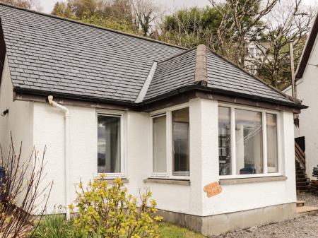
Start at the countryside centre at Morvich. There is a general information board at the centre, and parking for several vehicles, but you WILL need your own OS map. From the countryside centre simply walk down the paved road, past the hostel, to the end of the road where it turns left to cross the Abhainn Chonaig. Just across the bridge there is a signpost to the start of the footpath, turning right of the roadway.
Follow the footpath west and then north as it follows the course of the stream. The going is fairly level at this point and you pass through several farm fields with cattle grazing, with the stream and forestry plantation to your left.
After about 1 mile there is a fork in the trail and a signpost shows where the trail heads down the slope of the hill and crosses a small footbridge over the stream. On the far bank, the trail cuts diagonally across the slope of the hill, heading almost back the way you've come.
At the top of the wooded gorge beside the stream, you emerge into a cleared area, facing a forestry plantation and join a wide forestry road. This is the only part of the walk I found confusing. The trail is facing east (left) but you need to turn right (west) along the forestry road, in the direction of a ruined stone cabin.


From this point on the going is pretty straightforward. You pass the cabin on your right, and just keep following the forestry road as it turns north. You go through a gate and head uphill.
A road comes in from the right but you keep going uphill to a locked gate where the way forks. Just keep bearing right, following wooden forestry signs with red paint. The signs are set fairly low to the ground so might be awkward to spot at first, but they are there!

You pass over a low bridge at the northern tip of the forestry plantation and find yourself in open countryside. The path turns west and heads along a narrow glen, towards a distant gap in the hills.
This section is fairly rocky, but the going is not difficult. As I walk along I could see - and hear - herds of deer on the opposite hillside. It was Autumn, and the stags were bellowing challenges to each other.
You emerge at long last into open moorland at the top of the glen. This is the highlight of the trip for me. The scenery is incredible; the open landscape seems to stretch away for miles in all directions, with distant peaks seeming to call an invitation!

The route simply winds along the top of the moors for a mile, then begins to descend toward the falls. You can't see, or hear the falls at this point, and I started to wonder if I'd missed something. I hadn't; the trail loops back towards the east and rather peters out in a marshy area above the Abhainn Gaorsait.
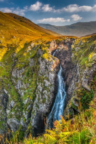
There is a sign warning not to go too close to the edge, but really, that's what you came for! You can see where the falls drop down a precipitous cliff face, tumbling down a sheer drop to the valley floor, unseen far below.
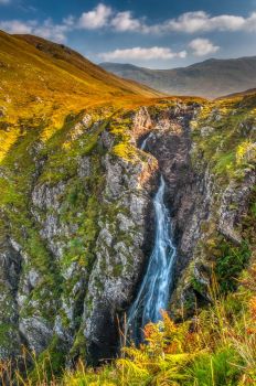
The trail winds down the side of the ravine and there are several good places to stop for a better view of the falls. There doesn't seem to be any place where you can see the entire falls, top to bottom, but that's because the drop is so high. I stayed well away from the edge, and I advise you do the same. There are no railings, and one slip on a wet rock could spell disaster. That said, the falls are stunning. The roar of the water is deafening, and the landscape is surreally beautiful.

The return trip is just a retracing of the way you came.
How long will it take?
Well, the total distance is about 5.5 miles each way from the countryside centre, making a total round trip of 11 miles or so. It took me roughly 6 hours, but I stopped to take a lot of photographs.
The scenery was so incredible that I found myself getting out my camera and setting up my tripod every hundred yards or so, and that took up a lot of time. A reasonably fit person should be able to make it in less time than I did, but I wouldn't recommend it unless you are used to vigorous activity.
Please use common sense; weather can change quickly in the Highlands. Wear good waterproof footwear and take a good OS map with you. The trail is not difficult to follow but if the weather turns bad visibility can be awkward.

The Falls of Glomach is included in our list of 22 Beautiful Scottish Waterfalls.