Snowdonia, known in Welsh as Eryri (land of the eagles), is a land of high peaks, steep, plunging valleys and open moorland bounded on the west by the Lleyn Peninsula and the Cardigan Coast. Rocky mountains, glacial lakes, waterfalls and wilderness compete for attention.
Prehistoric man and Celtic chiefs left their mark here. The Romans built roads and forts. Pilgrims visited. The Welsh Princes of Gwynedd reigned from mountain strongholds-armies disappeared into the vastness of the remote countryside, eluding their enemies. The English came to conquer and marked the landscape by building castles. Industry destroyed mountains.
Today's visitor can experience the culture of the past while enjoying the beauty of today. Snowdonia National Park's 840 square miles (1351 sq. km) stretches from the Conwy river in the north to Machynlleth in the south and eastwards to Bala. It includes the mountain ranges of Tryfan, the Glyderau, the Moelwynion, Aran and Arennig, Cader Idris and the most well known mountain, Snowdon, the highest peak south of the Scottish border at 3560 ft. (1113m.)
Bangor, a historic university and cathedral city, lies at the eastern entrance of the Menai Strait. This ancient town began in 525AD with the building of a monastery. There's an ornate Victorian pier-considered one of Wale's finest-that provides a delightful countryside view.
The Museum of Welsh Antiquities contains collections of prehistoric, Roman and other northern Wales finds. Nearby Penrhyn Castle is a country house pretending to be a castle. It was built for the slate magnate Lord Penrhyn and completed about 1834.

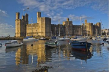
The town of Caernarfon is famous for its castle and medieval walls. The walls are 766yds (700m) long and are almost complete. They include eight towers and two gateways. Caernarfon Castle, on the Menai Strait, is the site of the investiture of the Princes of Wales. The first Prince of Wales, King Edward's son, was born here in 1283. More recently Prince Charles was invested here.
Encircled by Caernarfon, the Roman fort of Segontium - once the most western in the Empire-was occupied from 77 AD to c394 AD. The foundations are all that remain today.
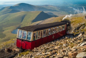
Llanberis is a popular mountain centre in the National Park. It is flanked by two lakes, Llyn Padarn and Llyn Peris. The beautiful Llanberis Pass is a not-to-be-missed driving adventure. From Llanberis, take the rack and pinion railroad to the summit of Mt Snowdon. It's a scenic wonder on a clear day.
The National Slate Museum is at nearby Pardarn Country Park. On view are the foundry, fitting shop, smithy, sawmill, carpenter's shop, pattern loft and all the old machinery used to dress the slate. Most spectacular is the 50.5 ft (15.4m) diameter water wheel that provided the power in the workshops. Roofing slate was made here for all of Britain.
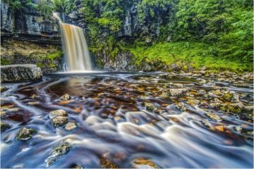
The Snowdonia National Park Visitor Centre is located at the Old Stables in Betws-y-Coed, a popular resort. There are many interesting bridges in the area. The iron Waterloo Bridge, built in 1815 by Thomas Telford, is inscribed "This arch was constructed in the same year the battle of Waterloo was fought". The famous Swallow Falls and its chasm are nearby. To the south of the village is the Fairy Glen, a narrow gorge of the River Conwy.
Blaenau Ffestiniog, once the centre of the slate quarrying industry, is now a tourist attraction. At the Llechwedd Slate Caverns, Victorian mining conditions can be observed, and you can learn how slate was mined on the Miner's Tramway tour or the Deep Underground tour.

Beddgelert, a wooded stone village located amid steep mountain slopes, lakes and wooded hillsides, was featured on a stamp in 1997 and won a Gold Award for villages in a Europe in Bloom competition. It's a desirable location for exploring the Snowdon mountain range.
Bala Lake, the longest lake in Wales, is a popular watersports centre. A narrow-gauge railway skirts the southern shore. This town was, at one time, the centre of the Methodist Church movement.
The Cardigan Coast and Bay area is known for its sandy beaches and holiday resorts. Barmouth is an old harbour town made popular by the Victorians. Look for the bridge built in 1866, with its 113 trestles and enjoy the famous Panorama Walk.
Porthmadog was a 19th-century terminus for shipping slate. Nearby Black Rock Sands provide a beach playground. Portmeirion is a famous Italianate village near Porthmadog.
Harlech Castle was made internationally famous by the song "Men of Harlech". It is now a World Heritage site. Part of its appeal is the viewpoint it commands from its 200ft high crag over Cardigan Bay, the Lleyn peninsula and the mountains of Snowdonia.
The Lleyn Peninsula is an area of remote bays and cliffs, wildlife- inhabited islands and coastal resorts. The largest coastal town is Pwlleheli with a long sandy beach and marina. It's a popular holiday resort. The old town still hosts a market, and the harbour is filled with pleasure craft. Nearby, in Aberech, is a large medieval church.
Aberdaron is the most westerly village on the Peninsula. It, too, has a sandy beach. Bardsey Island, two miles (3km) off the end of the peninsula, is an ancient place of pilgrimage.
The Island of Anglesey
The island of Anglesey is separated from the mainland by the fifteen-mile long Menai Strait, carved by glaciation during the Ice Age. The strait's tidal currents can reach up to 8 knots (15 km/h) in the narrow region between the island and mainland. Many ferry and boat accidents occurred before the bridges were built.
Anglesey's 125 miles (201 km) of coastline are a mix of rocky headlands, sandy bays and resort towns. The varied habitats of Anglesey mean that it abounds with birds, plants and other wildlife. Apart from the coastline, most of the island is agricultural or marshland. The entire island has been designated an Area of Outstanding Natural Beauty.

The beaches at Newborough and Red Wharf Bay are particularly fine. At low tide, Red Wharf Bay's sands encompass 10 square miles (25 sq. km), attracting waterfowl and wading birds.
Anglesey was the last stronghold of the Druids, who were finally eradicated here by the Roman conquerors around AD 63, and the island has been home to strange legends and myths ever since. It is riddled with standing stones and burial chambers. Cadw is the best source for the location of these ancient sites, with 14 on the Island under its care. One of particular note is Barclodiad y Gawres Burial Chamber.
The seaside resort of Beaumaris is home to beautiful Georgian buildings and Victorian terraces as well as black and white Tudor houses. Llywelyn the Great's wife, Joan (daughter of King John), is buried in the parish church. 15th-century pubs and an early 17th century Court House and Gaol add to the architectural diversity of the town. The Gaol is now a museum where visitors can see the terrors of prison life. Moated Beaumaris Castle, begun as part of Edward I's defences to keep Wales subdued, was never finished. It is a World Heritage listed site.

Plas Newydd, (not to be confused with the house of the same name at Llangollen) home of the Marquis of Anglesey, is an 18th-century house built by James Wyatt in both Classical and Gothic styles. It houses a massive mural painted by Rex Whistler and an exhibition about his work. It is two miles (3km) from the village of Llanfair PG, blessed with the longest place name in the world: Llanfairpwllgwyngyllgogerychwyrndrobwllllantysiliogogogoch, which means "St. Mary's Church by the white aspen over the whirlpool and St. Tysilio's Church by the red cave"). It's a 19th-century name adopted for its tourist value, and not the original name of the village. Call it Llanfair PG.
The town of Holyhead, located on Holy Island, eight miles (13km) long and four miles (6km) wide, is separated from Anglesey by a sandy strait. It is the largest town on Anglesey and is a popular destination for sports and beach activities. Ferries go from here to Dublin, Ireland. Ancient hut circles are found on Holyhead Mountain.
At the town of Llangefni, the Oriel Ynys Mon Museum contains displays on Anglesey's history, culture and environment.
For more in-depth information about Anglesey, Snowdonia and area:
North Wales Attractions
Tourist Information Centres
Hotels - Self Catering