Ordnance Survey maps - aterproof and normal OS maps at discount
Dinas Head Heritage Coast
Spectacular views make Dinas Head a delightful and uncrowded place to visit in Mid Wales.
Home > Countryside > Coasts > Dinas Head
SITE MAP

Home
spacer
Attractions

 England
 Scotland
   Wales

Regions
Anglesey & Snowdonia
Cardiff area
Carmarthenshire
Ceredigion
Mid Wales
North East Wales
Pembrokeshire
Swansea and Gower
Wye

Virtual Tour of Wales

Castles of Wales photo gallery

Attractions
Abbeys
Ancient Sites
Castles
Churches
Gardens
Historic Houses
Museums
Roman sites

Travel Resources
Tourist Info Centres
Travel links

Accommodation
Wales Hotels
Self Catering
Bed & Breakfast

. . . . . . . . . .

 London

Accommodation

 Hotels
 Hostels
 Bed & Breakfast
 Self catering

Travel Services
 Rail Tickets
 Car Rental
Tourist Info Centres
 England
 Scotland
 Wales
Heritage
 History
 Culture
Travel Directory
 England
 Wales
 Scotland
 B&B
 Hotels
 Tour Operators
 Car Rental
 Walking Holidays
 Waterways  Holidays
 more....
Fun

 Photo of the Day
 RSS Feeds
 Historic Attraction Quiz
 British History Quiz
 Monarch Mayhem
 This Day in British History

About
 Contact
 About us
spacer


Countryside


Dinas Head Heritage Coast

Dinas Head Heritage Coast

Description:
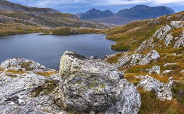
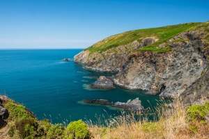
The headland at Dinas is one of the most spectacular along the Pembroksehire Coast (which is saying a great deal). At 463 feet in height, the cliffs at Dinas Head provide excellent views across Fishguard Bay to the south and Newport Bay to the north. The headland is under the care of the National Trust.

In May and June the woodlands here are thick with bluebells, and a nature trail wanders for 2 miles along the River Tywi.

Dinas Head is contained within the Pembrokeshire Coast National Park, and the Pembrokeshire Coast Path runs along the length of the heritage coast. Heather and gorse carpet the headland in late summer and fall.

Area Countryside attractions:

Pembrokeshire Coast National Park
A gently rolling plateau overlooking the rugged coastline. This is good birding area, with sanctuaries at Grasholm, Skomer, and Skokholm Islands, while Ramsey Island is renowned for its large grey seal population. More ...

Pembrokeshire Coast Path
The 186 mile path follows the heritage coast and takes in the entire length of the Pembrokeshire National Park. The walking is superb, the scenery breathtaking, as the path climbs along cliffs and beside sandy bays. Thankfully, this trail is more sparsely traveled than most other long-distance paths in Britain. More ...

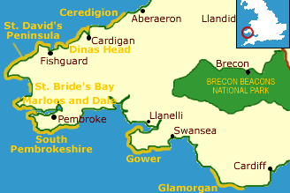
St. David's Peninsula Heritage Coast
The heritage coast stretches 50 miles, following the rugged contours of St. David's Peninsula from St. Brides Bay to Fishguard. The peninsula blends history and scenery to better effect than just about any area of Britain. More ...

Attractions in South Wales

Maps:
Get an Ordnance Survey map covering the Fishguard area - and get 10% off paper maps! (opens new window)

Top Links:
Pembrokeshire Attractions and Heritage
South Wales links

More
Heritage Coasts

Countryside Index

Contacts

Fishguard Harbour Tourist Information Centre
Passenger Concourse
The Harbour, Goodwick
Fishguard
Pembrokeshire SA64 0BU
Tel: +44 (0) 1348 - 872037

More Tourist Information Centres


Ordnance Survey
maps Special!

Up to 36% Discount
on Ordnance Survey maps

Ordnance Survey map

Plus - Free Shipping!

Ordnance Survey maps - free shipping image

New

Create your own personalised Ordnance Survey Site Centred maps

Centre your unique laminated Explorer or Landranger OS map on any UK postcode, grid reference or place name
Details

(Aqua3 laminated maps only)

Ordnance Survey maps
Explorer maps (1:25,000)
Landranger maps (1:50,000)
Routeplanner maps (1:625,000)
Road maps (1:250,000)
Touring maps

Laminated and paper maps

Receive up to 36% off the retail price laminated waterproof Ordnance Survey maps

and

(10% off regular paper OS maps!)
Landranger, Explorer, Routeplanner, Road maps and touring maps

Find your Ordnance Survey map