4 miles (138km)
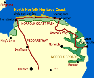
The Peddars Way starts on Knettishall Heath near Thetford, and follows generally flat fen country across Norfolk to the sea - a distance of some 46 miles.
Along the way the path follows an old Roman road through the Norfolk countryside to the beginning of the Norfolk Coast Path near Hunstanton. The Romans built the road as part of their successful efforts to subdue the rebellious Iceni tribe in 61 AD. The Iceni, led by Queen Boadicea (Boudicca), razed Colchester and London before being brought to bay. The Roman road brought troops and supplies deep into Iceni territory and probably linked with the garrison town of Colchester.
The name "peddar" was not applied to the path until the Middle Ages, when it seems to have been a generic term for a footpath. The route is an enjoyable mix of country lanes, footpaths, and tracks.
At Holme-next-the-Sea the path turns east along the coast and travels through the Norfolk Coast Area of Outstanding Natural lBeauty (AONB) to Cromer. The area is rich in salt marshes, dunes, and clay cliffs, as well as quiet villages notable for their flint and brick architecture.
The path then joins up with the Weavers Way and Angles Way to create a circuit of eastern Norfolk. If you go the other direction, the Peddar's Way joins up with the ancient Icknield Way to create a route all the way to Cornwall!
Highlights:
North Norfolk Heritage Coast
Titchwell and Cley Marsh bird Reserves
North Norfolk Heritage Coast
Titchwell and Cley Marsh bird Reserves
Youth Hostels:
Brandon, Hunstanton, Sheringham
Maps
Ordnance Survey maps covering the Peddar's Way and Norfolk Coast Path:
Explorer OS maps (Scale: 4cm = 1 km / 1: 25000) - best for walking
229, 236, 250, 251, 252
Landranger OS maps (Scale: 2cm = 1km / 1: 50000)
132, 133, 144
All OS maps are available at 10% off retail price, by special arrangement if you order through Britain Express. Both laminated and plain paper maps are available.
Guidebooks & Accommodation
Offa's Dyke Association
National Trail Guide: Peddars Way and Norfolk Coast Path, by Bruce Robinson, Aurum Press, £10.99
Langton's Guiide to the Peddars Way and Norfolk Coast Path, by Andrew Durham, Langton's Guides, £8.95
Walking the Peddars Way and Norfolk Coast Path with the Weavers Way, available from the Norfolk Area Ramblers Association (see below)
Stillwell's National Trail Companion by Tim Stillwell and Dean Conway, Stillwell Publications, £7.96 - lists accommodation on and near national trails throughout the UK and Ireland
The Rambler's Yearbook and Accommodation Guide published by the Rambler's Association, £4.99 - lists accommodation and walking resources.
Useful Contacts
Norfolk Ramblers Association
7 Lowther Road, Norwich, NR4 6QN
Peddars Way & Norfolk Coast Path Officer
The Old Courthouse
Baron's Close
Fakenham
Norfolk
NR21 8BE
Tel: 01328 850530
Website: www.nationaltrail.co.uk/peddarsway
7 Lowther Road, Norwich, NR4 6QN
Peddars Way & Norfolk Coast Path Officer
The Old Courthouse
Baron's Close
Fakenham
Norfolk
NR21 8BE
Tel: 01328 850530
Website: www.nationaltrail.co.uk/peddarsway
Best of Britain Express Art Prints