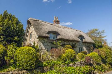
The sheep is the symbol of Yorkshire Dales National Park, and for good reason. This is sheep country, and the open fields are criss-crossed by patterns of dry stone walls marking the field boundaries. Small villages and farms cling to the sides of valleys and river banks, and the high ridge of the Pennine Range looms over the landscape.
Swaledale is the largest of the dales which make up the park, and the sheep which takes its name from this area grazes the high fells, while cattle occupy the river bottom.
There is excellent walking here, and in neighbouring Wensleydale. There is a visitor centre at Hawes, in addition to the Upper Dales Folk Museum.

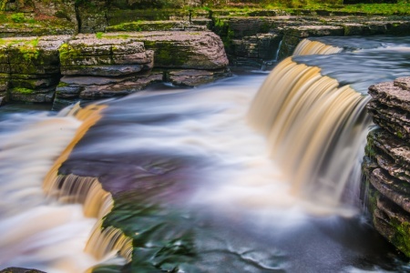
Near Hawes is Hardraw Force, an impressive waterfall with a sheer drop of 100 feet. You can actually pass right behind the fall of water, or take the steep walk to the top of Great Shunner Fell, for superb views. Further west, Malham Cove boasts a huge natural amphitheatre, as well as the National Park Information Centre at Malham village, and several enjoyable circular walks to nearby Malham Tarn.
How many dales are there?
This question is not as easy to answer as you might think! It depends how you count them, whether you include small 'side' dales that run at tangents from larger dales, and whether you include dales that are only partly inside the National Park boundaries.
Most dales are named for the river that runs through them, such as Swaledale for the Rive Swale and Wharfedale for the River Wharfe. The major exception to this rule is Wensleydale, which is named for the village of Wensley at the eastern end of the dale rather than the River Ure which runs through the dale itself.
To answer the question of how many dales there are, we turn to the Yorkshire Dales National Park official information, which lists 10 dales and three valleys (Lune Valley, Ingleton Glens and the Rawthey Valley). The 'official 10 dales' are:
- Arkengarthdale
- Coverdale
- Dentdale
- Littondale
- Malhamdale
- Ribblesdale
- Swaledale
- Wensleydale
- Widdale
- Wharfedale
Towns and Villages
Askrigg: a picturesque Dales village that served as the setting for the TV series All Creatures Great and Small
Aysgarth: a small village in Upper Wensleydale, famous for its lovely waterfalls and historic mill
Bedale: a historic market town at the eastern entrance to Swaledale
Castle Bolton: a tiny village in Swaledale, home to historic Bolton Castle
Grinton: an idyllic 'chocolate box' village in Swaledale
Hawes: a pretty market town in Wensleydale
Ingleton: a village in the western Yorkshire Dales, home to the Waterfalls Trail
Leyburn: a pretty market town, the gateway to Wensleydale and the National Park
Malham: a delightful village north of Skipton
Middleham: a small market town near Leyburn, home to Middleham Castle
Muker: an attractive village in Swaledale with a lovely Elizabethan church
Pateley Bridge: an attractive market town in Nidderdale, in the northern Yorkshire Dales
Reeth: the 'capital of Swaledale' at the junction of Swaledale and Arkengarthdale
Skipton: a market town in the south-eastern corner of the National Park, home to Skipton Castle
Historic Sites
Barden Bridge: a 17th-century bridge across the River Wharfe
Barden Tower: a 15th-century fortified manor house overlooking Barden Bridge
Bolton Abbey: scenic ruins beside the River Wharfe
Jervaulx Abbey: a 12th-century Cistercian monastery by the River Ure
Middleham Castle: the medieval fortress of the powerful Neville family and Richard III's boyhood home
Ribblehead Viaduct: a stunning Victorian feat of engineering, carrying the Settle to Carlisle railway line
Skipton Castle: perhaps the best-preserved medieval castle in England, begun in the 12th century
Parcevall Hall Gardens: a delightful 24-acre garden in the heart of Wharfedale
Swaledale Museum: this delightful little museum in Reeth explores the rich heritage of Swaledale and Arkengarthdale
Thorpe Perrow Arboretum: a stunning 100-acre arboretum near Bedale
Natural Wonders
Aysgarth Falls: a wonderfully picturesque series of three waterfalls
Catrigg Force Waterfall: a hidden waterfall reached by a lovely dales walk from Stainforth
Gordale Scar: a limestone escarpment near Malham
Hardraw Force: a waterfall with the longest unbroken drop in the north (100 feet)
Ingleton Waterfalls Trail: a famous circular walk taking in five dramatic waterfalls
Janet's Foss Waterfall: a peaceful waterfall near Malham
Malham Cove: a natural amphitheatre near Kirkby Malham
Mill Gill Force Waterfall: a lovely waterfall near Askrigg
The Buttertubs: limestone potholes once used to keep butter cool by local farmers
The Strid: A narrow gorge on the River Wharf near Bolton Abbey
Winskill Stones: a 74-acre nature reserve near Settle, with wonderfully scenic limestone pavement and limestone meadows
More attractions:
Clapham: outstanding nature trail begun by Reginald Ferrer. The trail passes Ingleborough Cave, perhaps the finest in the North of England.Southerdale Scar: Wildlife reserve with fascinating limestone pavements
Explorer OS maps (Scale: 4cm = 1 km / 1: 25000) - best for walking
EX030 Yorkshire Dales- North & Central
EX002 Yorkshire Dales South & West areas
Landranger OS maps (Scale: 2cm = 1km / 1: 50000)
LR099 NORTHALLERTON & RIPON, PATELEY BRIDGE / LAYBURN
LR092 BARNARD CASTLE / RICHMOND
Contact:
Yorkshire Dales National Park Authority
Yoredale, Bainbridge
Leyburn
North Yorkshire
DL8 3EL
OR
Yorkshire Dales National Park Authority
Colvend
Grassington
Skipton
North Yorkshire
BD23 5LB
website
Related:
Yorkshire Travel Guide
Northeast England