Description
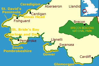
The heritage coast runs for 33 miles from Caswell Bay in the south to Salthouse point on the north shore of the Gower Peninsula. The approach to the peninsula is guarded by the urban sprawl of Swansea, but once the city has been left behind, Gower is a place of great natural scenic beauty.
Be warned, the Gower peninsula can be crowded in the summer months, especially the bathing beaches in the south and west.
The limestone cliffs of the south coast of Gower are riddled with caves, notably at Minchin, near Pennard, and Bacon Hole. Remains of hyena, elephant, bison, and rhinoceros have been found in the larger caves, which can be visited via steep, narrow paths.
The northern coast of the peninsula is a different affair entirely, made up of mudflats and salt-marshes, with wading bird habitats.
Worms Head, near Rhossili, is probably the most photographed feature along the Gower coast. The 'Worm' is a low headland joined to the mainland by a natural causeway only at low tide. The headland and the surrounding cliffs are protected as a nature reserve, and a reserve centre operated by the Countryside Council for Wales is housed in an old coastguard lookout.
Seals and porpoises are common visitors to Worms Head, and there is also a National Trust Visitor Centre. There are two Stone Age chambered tombs on Rhossili Down, and Iron Age hill forts on the cliffs.
At the north end of Rhossili Bay is Bury Holms, yet another island accessible only at low tide. The island was the home of 6th-century hermit St. Cenydd, and the remains of a medieval church can still be seen.
The Gower Heritage Centre at Parkmill is housed in a working 14th-century water-powered corn and sawmill. Aside from information on the Gower area, the centre aims to give visitors a taste of what daily life was like here a century or more ago with hands-on "living history" exhibits.
Area Countryside attractions
Brecon Beacons National Park
This is walking country and the peaks and valleys are crisscrossed by numerous waymarked trails. Well, not totally walker's country; they must share the Beacons with sheep, who vastly outnumber the humans here. More ...
Gower Area of Outstanding Natural Beauty
The very first AONB, Gower is blessed with a wide variety of outstanding scenery, from the limestone headlands at Oxwich Bay to the salt-marshes and dunes in the north. Inland, the landscape includes five different nature reserves set in heath, grasslands, and oak woodlands.
Maps: OS Landranger series #159
Contact
Gower Heritage Centre
Parkmill
Gower
Swansea
SA3 2EM
Email