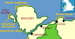
Ordnance Survey maps - aterproof and normal OS maps at discount
Holyhead Mountain Heritage Coast
The rocky western coast of Holy Island is home to a marvellous variety of seabird life.

Home > Countryside > Coasts > Holyhead
SITE MAP 

Home
spacer
Attractions

 England
 Scotland
   Wales

Regions
Anglesey
Cardiff
Carmarthenshire
Ceredigion
Mid Wales
North Wales (Snowdonia)
Pembrokeshire
Swansea and Gower
Wye

Virtual Tour of Wales

Castles of Wales photo gallery

Attractions
Abbeys
Ancient Sites
Castles
Churches
Gardens
Historic Houses
Museums
Roman sites

Travel Resources
Tourist Info Centres
Travel links

Accommodation
Wales Hotels
Self Catering
Bed & Breakfast

. . . . . . . . . .

 London

Accommodation

 Hotels
 Hostels
 Bed & Breakfast
 Self catering

Travel Services
 Rail Tickets
 Car Rental
Tourist Info Centres
 England
 Scotland
 Wales
Heritage
 History
 Culture
Travel Directory
 England
 Wales
 Scotland
 B&B
 Hotels
 Tour Operators
 Car Rental
 Walking Holidays
 Waterways  Holidays
 more....
Fun

 Photo of the Day
 RSS Feeds
 Historic Attraction Quiz
 British History Quiz
 Monarch Mayhem
 This Day in British History

About
 Contact
 About us
spacer

  
Countryside


Holyhead Mountain Heritage Coast
Holyhead Mountain Heritage Coast, Holy Island, Wales

Description:
This heritage coast runs for 8 miles up the wesern shore of Holy Island from the bathing beaches of Trearddur Bay to the dramatic cliffs at North Stack.

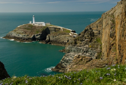
The cliffs and RSPB birdwatching station near the lighthouse at Ellins Tower near South Stack draw ornithologists like a magnet. Up to 4,000 pairs of seabirds mate at South Stack every year, including colonies of puffins, guillemots, razorbills, choughs, and peregrins. There is also a sizeable grey seal population. There is an interpretive centre at Ellins Tower.

The spectacular South Stack Lighthouse was built in 1809 to warn ships of the treacherous reefsat this most westerly point of Holy Island. Visitors may now descend over 400 steps to the lighthouse, which has been restored after a long period of closure. Clifftop paths make for excellent walking, but visitors are warned to stay on the marked trails.

Nearby, the Iron Age hillfort and prehistoric hut circles on Holyhead Mountain itself are impressive reminders of this remote island's ancient past. Those energetic enough to climb 718 feet to the top of the mountain will be rewarded with clear views across the Irish sea to the Irish mainland and equaly fine views to Snowdonia on the Welsh side.

Area Countryside attractions:
Anglesey AONB
This Area of Outstanding Natural Beauty takes in almost the entire coastline of the Isle of Anglesey. Steep limestone cliffs and sandy beaches on the island's east shore contrast with rolling sand dunes in the southwest.

Holyhead Breakwater Country Park
A disused quarry just outside Holyhead has been transformed into a walker's paradise of nature trails, with a large seabird population and an interpretive centre for visitors.

Attractions in North Wales

Maps:
Ordnance Survey Landranger map #114

Links:
Anglesey Tourism
North Wales links

More
Heritage Coasts

Countryside Index

Contacts

For birdwatching, contact the RSPB at
Ellin's Tower Seabird Centre
South Stack, Holyhead
The centre is open from Easter to mid September from 11am - 5pm seven days a week and admission is free. For further information phone 01407 764973

South StackLighthouse visitor information:
Department of Leisure and Heritage,
Isle of Anglesey County Council
Tel: 01248 724444
E-mail here
The lighthouse is open Easter to the end of September, 11.00 a.m to 5.00 p.m each day.


Ordnance Survey
maps Special!

Up to 36% Discount
on Ordnance Survey maps

Ordnance Survey map

Plus - Free Shipping!

Ordnance Survey maps - free shipping image

New

Create your own personalised Ordnance Survey Site Centred maps

Centre your unique laminated Explorer or Landranger OS map on any UK postcode, grid reference or place name
Details

(Aqua3 laminated maps only)

Ordnance Survey maps
Explorer maps (1:25,000)
Landranger maps (1:50,000)
Routeplanner maps (1:625,000)
Road maps (1:250,000)
Touring maps

Laminated and paper maps

Receive up to 36% off the retail price laminated waterproof Ordnance Survey maps

and

(10% off regular paper OS maps!)
Landranger, Explorer, Routeplanner, Road maps and touring maps

Find your Ordnance Survey map