Ordnance Survey maps - aterproof and normal OS maps at discount
Spurn Head Heritage Coast
Sand, shingle, and birds galore at the mouth of the Humber River, Yorkshire.

Home > Countryside > Coasts > Spurn Head
SITE MAP 

Home
Accommodation
 Hotels
 Hostels
 Bed and Breakfast
 Self catering
Attractions

England
  Yorkshire

Yorkshire Travel

 Scotland
 Wales
Travel Services
 Rail Tickets
 Car Rental
Tourist Info Centres
 England
 Scotland
 Wales
Heritage
 History
 Culture
Travel Directory
 England
 Scotland
 Wales
 B&B
 Hotels
 Tour Operators
 Car Rental
 Walking Holidays
 Waterways  Holidays
 more....
About

 Contact
 About us


Countryside


Spurn Head Heritage Coast
Spurn Heritage Coast

Description:
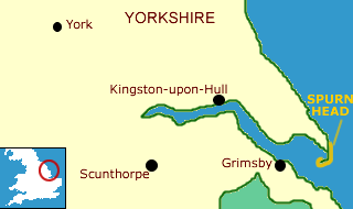
The heritage coast consists of a long, curving hook of shingle and sand arcing into the mouth of the Humber River. The coast is a stopover point for thousands of migrating birds in the spring and autumn, and a special observatory has been set up to allow bird-lovers to monitor their feathered friends.

The area has been recognised as a Nature Reserve by the Yorkshire Wildlife Trust, and visitors can expect to see seals and butterfly species in addition to the birds.

Despite its pleasant appearance, Spurn Head has a history as a treacherous place for shipping; indeed the lifeboat station there is the only one in Britain manned by a permanent crew.

Area Countryside attractions:
The Wolds Way
This long distance path begins at Filey, and curves inland following the escarpment of the Yorkshire Wolds through open countryside to Kingston-upon-Hull. More ...

Flamborough Headland Heritage Coast
North along the coast from Spurn is Flamborough Headland, a dramatic chalk cliff, and home to Britain's only mainland gannet colony.

Cleveland Way
The Cleveland Way National Trail is a walk of contrasts. For most of its route it runs through the wild beauty of the North York Moors National Park. Reminders of a colourful past abound along the trail, from the remains of the marvelous Cistercian abbey at Rievaulx to the ruins of Roman signaling stations that dot the coastline. More ...

Attractions in the Northeast

Maps
OS Landranger series #113

Yorkshire links

More
Heritage Coasts

Countryside Index

Contacts
Spurn Heritage Coast Project
Eastington, Hull
Humberside HU12 20SU


Ordnance Survey
maps Special!

Up to 36% Discount
on Ordnance Survey maps

Ordnance Survey map

Plus - Free Shipping!

Ordnance Survey maps - free shipping image

New

Create your own personalised Ordnance Survey Site Centred maps

Centre your unique laminated Explorer or Landranger OS map on any UK postcode, grid reference or place name
Details

(Aqua3 laminated maps only)

Ordnance Survey maps
Explorer maps (1:25,000)
Landranger maps (1:50,000)
Routeplanner maps (1:625,000)
Road maps (1:250,000)
Touring maps

Laminated and paper maps

Receive up to 36% off the retail price laminated waterproof Ordnance Survey maps

and

(10% off regular paper OS maps!)
Landranger, Explorer, Routeplanner, Road maps and touring maps

Find your Ordnance Survey map