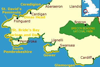
Description
The heritage coast runs for five miles along the open shore of St. Brides Bay, between the headlands of St. David's and Marloes. The actual village of St. Bride's is nowhere near the heritage coast - in fact, it is encompassed by the Marloes and Dale Heritage Coast further south. St. Brides Bay is an area of high cliffs and broad, sandy beaches, popular with holidaymakers in the summer months.
Despite this, there are secluded pockets along the coast that seem to have escaped the towel and bucket brigade. Druidston Haven beach is one such - there are steep cliffs above the sand, with pebbled beach above the high tide line.
Druidston itself was not named after the old Celtic priests, but apparently, after a medieval knight named Dure. The cliffs at Druidston have been declared a Site of Special Scientific Interest (SSSI), a distinction shared by the cliffs at Nolton Haven, another sheltered beach along the coast.
There is excellent wheelchair access to Haroldston Chins, just to the south of the heritage coast, which provides wonderful views across the Bay. The Pembrokeshire Coast Path (see below) provides excellent walking along the cliffs throughout the area of the heritage coast.
Area Countryside attractions
Pembrokeshire Coast National Park: A gently rolling plateau overlooking the rugged coastline. This is good birding area, with sanctuaries at Grasholm, Skomer, and Skokholm Islands, while Ramsey Island is renowned for its large grey seal population.
Pembrokeshire Coast Path
The 186-mile path follows the heritage coast and takes in the entire length of the Pembrokeshire National Park. The walking is superb, the scenery breathtaking, as the path climbs along cliffs and beside sandy bays. Thankfully, this trail is more sparsely travelled than most other long-distance paths in Britain. More ...
Marloes and Dale Heritage Coast
The cliffs along the heritage coast are generally rugged, but there is a good sandy beach at Marloes Sands. The Sands are a Site of Special Scientific Interest (SSSI) due to the steep cliffs of Silurian rocks that fringe the beach. The heritage coast includes Skomer Island, a nature reserve famous for its large puffin population and bird breeding areas. More ...
Maps:
OS Landranger series #157
Contact
Pembrokeshire Coast National Park
Winch Lane
Haverfordwest, SA61 1PY