Ordnance Survey maps - aterproof and normal OS maps at discount
Tennyson Heritage Coast
Tennyson himself lived on the coast which bears his name, and countless visitors to the Isle of Wight share his appreciationof this lovely coastline.

Home > Countryside > Coasts > Tennyson
SITE MAP 

Home
Accommodation
 Hotels
 Hostels
 B&B
 Self catering
Attractions
 England
  Isle of Wight

Travel Guide
Castles
Gardens
Historic Buildings
Historic Houses
Museums
Roman

Travel Resources
Tourist Information Centres
Travel links

Accommodation
Isle of Wight Hotels
  Ventnor
Bed & Breakfast
Self Catering


 Scotland
 Wales
 London
Travel Services
 Tours
 Rail Tickets
 Car Rental
Tourist Info Centres
 England
 Scotland
 Wales
Heritage
 History
 Culture
Travel Directory
 England
 Wales
 Scotland
 B&B
 Hotels
 Tour Operators
 Car Rental
 Walking Holidays
 Waterways  Holidays
 more....
About
 Contact
 About us
spacer

  
Countryside


Tennyson Heritage Coast

Description:
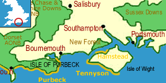
The Tennyson Heritage Coast is named after Alfred, Lord Tennyson, the Poet Laureate, who lived at Faringford House overlooking Freshwater Bay.

The coast begins at Totland on the Solent, and stretches along the southwest shore of the Isle of Wight nearly to Ventnor. Along the way it passes the dramatic chalk stack of The Needles promontory and skirts shingle beaches and high cliffs - and a petrified forest of fossilized conifers! A walking path runs the length of the coast, providing wonderful views over the Solent in the north and the English Channel in the south.

The chalk stacks of The Needles are perhaps the most notable feature on the coast. On Headon Hill, just to the north of The Needles, lies a Bronze Age burial mound dating to perhaps 1500 BCE.

At Alum Bay the cliffs are stained in multi-coloured hues by mineral deposits. The colours run in vertical bands up the cliffs, which have been a popular seaside gathering place since Victorian times.

The inaccessible undercliffs along the coast provide a breeding ground for the Glanville Fritillary butterfly, a species found only on the Isle of Wight and the Channel Islands.

Area Countryside attractions:
Isle of Wight AONB
Almost exactly half of the area of the Isle of Wight has been designated an Area of Outstanding Natural Beauty (AONB), a recognition of its scenic and ecological value. The AONB takes in the Hamstead and Tennyson Heritage Coasts, and the lovely chalk downlands than extend into the interior of the island.

Hamstead Heritage Coast
This coast stretches along the northwestern (Solent) shore of the Isle of Wight from Yarmouth harbour to Thorness Bay, near Cowes. The coast is a region of salt marshes and mud flats backed by low cliffs of clay. At Bouldnor, near Hamstead, these cliffs are especially rich in fossils - it has been claimed that this exposed deposit of Oligocene fossils embedded in the clay is the richest on earth.

More South Coast attractions

Maps:
OS Landranger series #196

Links
Naturally Wight - Coastal Wight
Wightinfo.com
Isle of Wight links

More
Heritage Coasts

Countryside Index

Contacts

AONB Officer
AONB Project The Gatehouse
Forest Rd, Newport
Isle of Wight PO30 5YS
Tel: (01983) 822118
Fax: (01983) 522812

Policy and Environment Manager
Council Offices Sea Close
Fairlee Rd, Newport
Isle of Wight PO30 2QS
Tel: (01983) 821000

Isle of Wight Council
PO Box 44, Newport
Isle of Wight, PO30 5WL
Tel: +44(0)1983 524343
Fax: +44 (0)1983 521606

Tourist Information Centres


Ordnance Survey
maps Special!

Up to 36% Discount
on Ordnance Survey maps

Ordnance Survey map

Plus - Free Shipping!

Ordnance Survey maps - free shipping image

New

Create your own personalised Ordnance Survey Site Centred maps

Centre your unique laminated Explorer or Landranger OS map on any UK postcode, grid reference or place name
Details

(Aqua3 laminated maps only)

Ordnance Survey maps
Explorer maps (1:25,000)
Landranger maps (1:50,000)
Routeplanner maps (1:625,000)
Road maps (1:250,000)
Touring maps

Laminated and paper maps

Receive up to 36% off the retail price laminated waterproof Ordnance Survey maps

and

(10% off regular paper OS maps!)
Landranger, Explorer, Routeplanner, Road maps and touring maps

Find your Ordnance Survey map