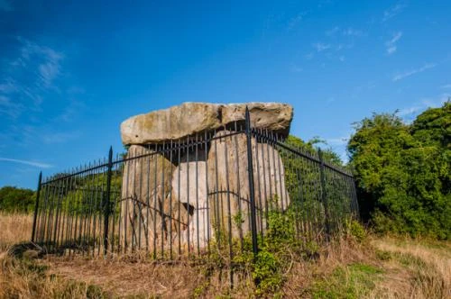
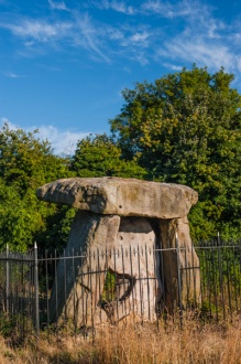
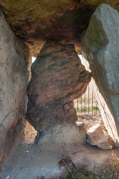
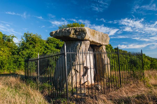
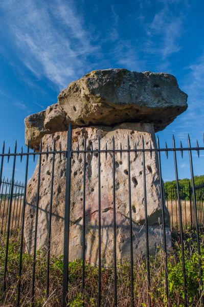
Kit's Coty House is a dolmen burial chamber consisting of three upright stones and a capstone. The capstone is huge, about 4 metres by 2.7 metres in width. Nearby is Little Kit's Coty, also known as the Countless Stones.
Kit's Coty is oriented east to west, with a dummy entrance, or burial chamber, at the east end. It would have originally been covered in earth to create a large mound.
Visiting Kit's Coty
To say that its a challenge to find Kit's Coty is an understatement; its extremely difficult unless you happen to know where to look. There are no apparent signposts, at least none that we could find, and if it had not been for the assistance of a friendly local we found in the Lower Bell pub, we'd still be looking!
The dolmen is located just off the North Downs Way trail, in a field south of Chatham Road, immediately west of the A229, at grid reference TQ744608. There is no parking on Chatham Road itself, but our local friend helped us out. Take the Old Chatham Road (signed Kit's Coty Estate) and use a convenient layby just before it joins Chatham Road at its northern end.
The layby is at grid reference TQ746609. Cross Chatham Road to a set of stone steps with a railing where you can see a National Trails sign for the North Downs Way. The trail leads downhill through a shady tunnel of trees for 300 yards or so until you come to a gap in the trees to your right (west). You can see the dolmen through the gap in the trees.
Again, there is no signpost, but you really can't miss it. There is a small information plaque beside the dolmen, which is protected by a set of iron railings.
Little Kit's Coty
A visit to Kit's Coty can be combined with Little Kit's Coty (the Countless Stones), which are about 400 yards away down the hill. Though the distance isn't great, it does require some determination!
To reach Little Kit's Coty simply carry on down the hill, following the North Downs Way to a road junction. The trail crosses Rochester Road at an angle to your left, where you can see a sign labelled 'Pilgrims Way'. Technically you could carry on along Rochester Road to the south-west for 100 yards until you come to a brown English Heritage footpath sign, but the road is extremely busy, and there is no verge or footpath to speak of.
What we did was to follow the Pilgrims Way for 25 yards and then go through a gap in the hedge to a farm field. We walked along the edge of the field, parallel to Rochester Road, making for a belt of trees that jut out into the field. The burial site is inside the treed area, protected by an iron railing.
Please be careful to avoid damaging the field fencing and crops! It literally takes no more than 10 minutes to walk between the two burial sites; the major problem is simply knowing where they are and avoiding traffic when crossing roads!
More Photos

About Kit's Coty House
Address: Aylesford,
Kent,
England
Attraction Type: Prehistoric Site
Location: Off the A229 two miles north of Maidstone, on the North Downs Way long-distance trail. Open access.
Website: Kit's Coty House
English Heritage - see also: English Heritage memberships (official website)
Location map
OS: TQ744608
Photo Credit: David Ross and Britain Express
HERITAGE
 We've 'tagged' this attraction information to help you find related historic attractions and learn more about major time periods mentioned.
Find other attractions tagged with:
burial chamber (Historical Reference) -
NEARBY HISTORIC ATTRACTIONS
Heritage Rated from 1- 5 (low to exceptional) on historic interest
Little Kit's Coty - 0.3 miles (Prehistoric Site) ![]()
Aylesford Priory (The Friars) - 1.8 miles (Abbey) ![]()
Burham, St Mary's Church - 1.8 miles (Historic Church) ![]()
Maidstone Museum & Bentlif Art Gallery - 3.1 miles (Museum) ![]()
Paddlesworth, St Benedict's Church - 3.8 miles (Historic Church) ![]()
Restoration House - 4.6 miles (Historic Building) ![]()
Rochester Castle - 4.7 miles (Castle) ![]()
Rochester Cathedral - 4.7 miles (Cathedral) ![]()