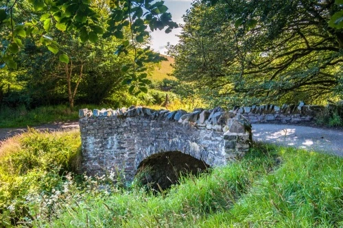
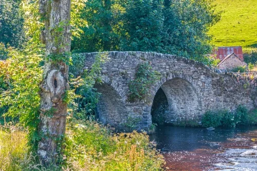
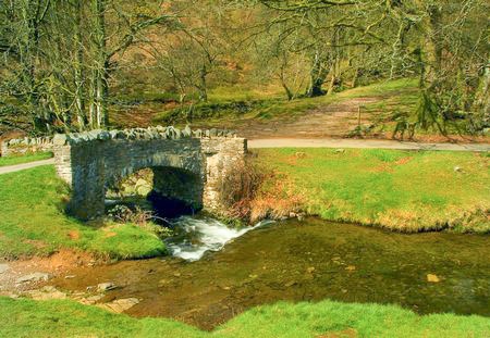
Robber's Bridge (sometimes known as Robbers Bridge) is a picturesque stone bridge across Weir Water, east of Oare Church in the heart of Exmoor's Doone Valley.
History
Many visitors, not surprisingly, link the bridge to RD Blackmore's classic novel Lorna Doone and assume that the bridge is named for the Donne family of outlaws. Even the official tourism website for the region, Visit Exmoor, says that the bridge is 'reputed to be the site of a Doone robbery'.
In fact, the bridge is not named for the fictional Doones, but after very real outlaws who roamed the area, outlaws whose exploits inspired Blackmore to create his fictional characters.
Richard Doddridge Blackmore's grandfather served as the rector of Oare Church from 1809-1842, and the writer drew on Exmoor history to create his tale of stout John Ridd and his love for Lorna Doone, published in 1869. It seems likely that the bridge got its name from these real-life outlaws, bandits who preyed on travellers in this remote location.
With that historical background out of the way, what about the bridge itself?
The single-arched span is of simple construction and uncertain age. We do know that it dates to at least 1842 for it appears in a tithe map dated that year.
It is, somewhat surprisingly, not listed by English Heritage, so presumably does not meet their standards for historical importance. It is certainly old, but no one seems to know how old. It is roughly 3.5m across (11.5 feet) and 2.3m wide (7.5 feet).
The bridge carries the narrow lane Porlock Hill to Oare. Just east of the bridge (the Oare side) there is a parking area. There is a grassy lawn near the bridge that has become a popular spot for picnics.
Be aware that the minor road to Oare is extremely narrow, with few passing places. It can be intimidating the first time you drive it!
Getting There
From the A39 west of Porlock turn off on the minor road to Oare. The road descends a steep hill and runs briefly beside Weir Water before you come to the parking area on your right. From there it is a stone's throw to the bridge. Alternatively, you can take a footpath from the A39, near the Culbone Inn. From the pub to the bridge is about 1.2km.
About Robber's Bridge
Address: Doone Valley, Oare, Exmoor, Somerset, England
Attraction Type: Historic Building - Bridge
Location: On the minor road between Porlock Hill and Oare village, off the A39. There is a parking area just east of the bridge.
Location map
OS: SS820464
Photo Credit: David Ross and Britain Express
NEARBY HISTORIC ATTRACTIONS
Heritage Rated from 1- 5 (low to exceptional) on historic interest
Oare, St Mary's Church - 1.2 miles (Historic Church) ![]()
Culbone, St Beuno's Church - 2 miles (Historic Church) ![]()
Brendon, St Brendan's Church - 4 miles (Historic Church) ![]()
Holnicote Estate - 5.6 miles (Countryside) ![]()
Bury Castle - 6.1 miles (Prehistoric Site) ![]()
Selworthy, All Saints Church - 6.2 miles (Historic Church) ![]()
Withypool, St Andrew's Church - 7 miles (Historic Church) ![]()
Valley of Rocks - 7.2 miles (Countryside) ![]()
Nearest Holiday Cottages to Robber's Bridge: