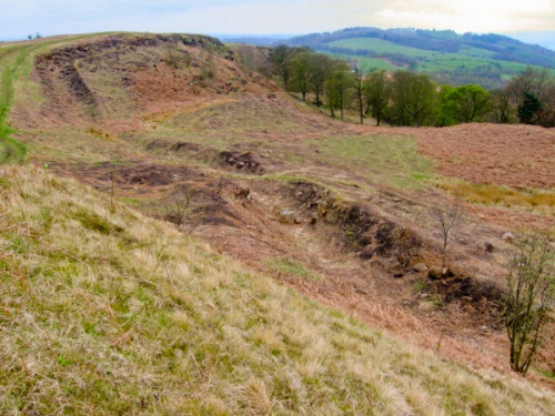
Only an outer ditch and a pair of beacon platforms survive of this Antonine Wall fort atop Croy Hill. The nature of the rocky terrain meant that the Romans were not able to dig a ditch as they normally would, but had to cut through solid rock to create a defensive barrier outside the Wall.
Croy Hill Roman Fortlet is small, measuring 270 ft x 243 feet, enclosing an area of 1.5 acres. The fort was joined to the wall on its northwest side and was defended by three ditches on the southwest and two ditches on the southeast.
Within the fort is a large well and a rectangular bath house lies just outside the northern corner. Excavations at Croy Hill revealed that the 2nd-century fort lies atop an earlier Roman camp, which has been linked - though with precious little evidence - to the 1st-century campaigns of Agricola in Scotland.
So here on one site, you have remains of a fort, a later fortlet, a temporary marching camp, and two raised platforms used as signal towers.
It is not surprising that Croy Hill was used for signalling; at 120m above sea level it is one of the highest points on the Antonine Wall and it offers wide-reaching views from the Firth of Forth in the east, the Kilsyth Hills to the north, and Bar Hill, the next fort to the west.
Excavations revealed foundations of a granary, headquarters building, a stone-lined well, and a shrine with an altar to nymphs. Artefacts uncovered during the excavations included coins from the reigns of Domitian (AD 81-96) and Trajan (AD 98-117).
Later investigation found a fortlet some 80m west of the main fort, and fragments of pottery suggesting that the hill was settled before the coming of the Romans.
About Croy Hill Roman Fortlet
Address: Antonine Wall, Croy, Strathclyde, Scotland
Attraction Type: Roman Site
Location: Off the B802 between Croy and Dullatur. Car park at the west end of Croy, then by path to the summit of Croy Hill.
Website: Croy Hill Roman Fortlet
Historic Scotland
Location map
OS: NS725762
Photo Credit: Chris Wimbush, licensed for reuse under the Creative Commons Licence
Opening Details: Open access site, usually accessible at any reasonable time
POPULAR POSTS
HERITAGE
 We've 'tagged' this attraction information to help you find related historic attractions
and learn more about major time periods mentioned.
We've 'tagged' this attraction information to help you find related historic attractions
and learn more about major time periods mentioned.
Historic Time Periods:
Find other attractions tagged with:
1st century (Time Period) - 2nd century (Time Period) - Roman (Time Period)
NEARBY HISTORIC ATTRACTIONS
Heritage Rated from 1- 5 (low to exceptional) on historic interest
Bar Hill Fort - 1.2 miles (Roman Site) 
Colzium Estate and Garden - 1.4 miles (Garden)
Dullatur - 2.3 miles (Roman Site) 
Antonine Wall, Castlecary Roman Fort - 4.3 miles (Roman Site)
Antonine Wall, Seabegs Wood - 5.7 miles (Roman Site)
Antonine Wall, Rough Castle - 7.2 miles (Roman Site)
Watling Lodge (Antonine Wall) - 8.8 miles (Roman Site)
Battle of Bannockburn Heritage Centre - 10 miles (Museum)
Nearest Holiday Cottages to Croy Hill Roman Fortlet:
Nearby accommodation is calculated 'as the crow flies' from Croy Hill Roman Fortlet. 'Nearest' may involve a long drive up and down glens or, if you are near the coast, may include a ferry ride! Please check the property map to make sure the location is right for you.

Stirling, Central Scotland
Sleeps: 4
Stay from:£621 - £1,754