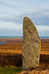
Unlike some prehistoric monuments in the Western Isles, it is actually quite easy to get to the stone; it is located immediately downhill of a modern water reservoir and the access road to the reservoir leads almost directly to the stone.
There is a small parking area just above the stone and when I visited a handy stile allowed easy access over the barbed wire fence! If the access road to the reservoir is closed, it should be a fairly easy 10-minute walk uphill to reach the stone, which is easily visible from the main road.
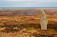
The stone is just over 17' high, 4 3/4' wide and 2' in depth and probably dates to the 3rd millennium BCE. It has a distinct taper towards the top. The thick moss and gorse surrounding the stone hide a variety of other smaller stones which seem intriguingly placed in relation to the upright larger stone.
Are they related? It isn't easy to see any alignment due to the level of the peat moss, but it does make me wonder if the main stone was the focal point of a larger arrangement of stones. The stone is set on a small terrace, or platform, in the slope of the hill. I'm not aware of any study suggesting that the terrace is manmade, but it certainly does look that way.
Note: It can be confusing to separate this stone with another of the same name on North Uist. Both are on the slope of hills called Beinn a' Charra and both are sometimes called An Carra Standing Stone. We're going with the quasi-official RCAHMS designation, which calls the South Uist stone An Carra, and the North Uist stone Beinn a' Charra. Just so you know.
 We've 'tagged' this attraction information to help you find related historic attractions and learn more about major time periods mentioned.