Salford is a peaceful Oxfordshire village set in farmland about 1.5 miles from the historic market town of Chipping Norton. The Shakespeare's Way long-distance trail leads across the fields from Chipping Norton to Salford, and crosses the small brook, a tributary of the River Evenlode, that gives Salford its name.
The name Salford comes from the Old English Sealhford, meaning the ford by the willow trees.
Or does it?
That's the typical explanation, but there is another possibility; that the name comes from an old salt track, a route used by traders carrying salt from the Midlands to London. The salt route later became a turnpike road and, still later, the A44.

History
The history of Salford goes back as far as the 8th century. A charter of AD 777 states that King Offa of Mercia granted an estate at Salford to the monks of Evesham Abbey. Some doubt has been cast on the authenticity of this charter; it may have been a much later forgery aimed at proving the monk's claim to the estate.
There were two manors at Salford at the time of the Norman Conquest. The Domesday Book of 1086 records one forming part of a larger estate that included Chastleton and Cornwell. This was held by the Norman lord Roger de Lacy at the time of the Domesday Book.
The other estate at Salford was also part of a much larger estate claimed partly by Odo, Bishop of Bayeux and half-brother of William the Conqueror and partly by the Archbishop of York.
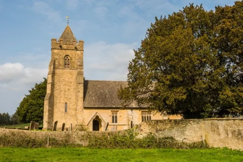
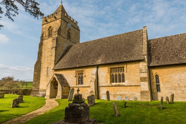
The most interesting historical building in Salford is the 12th-century parish church, dedicated to St Mary. The church stands at the western edge of the village, with a tower that is visible for several miles. In the field beyond the churchyard you can see the earthworks that are the only reminders of a long-vanished manor house and gardens.
8th or 15th century?
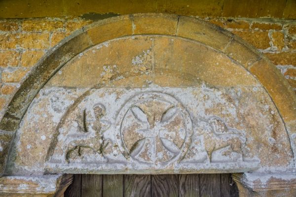
As for the church itself, it was comprehensively restored in 1853 by the prominent Victorian architect GE Street. Thankfully, Street preserved several Norman features from the earlier building, including the south doorway and a blocked north doorway with a 12th-century tympanum under the arch. The tympanum is carved with the Zodiac figures of Sagittarius (a centaur bending his bow) and Leo, the lion, flanking a Maltese cross.
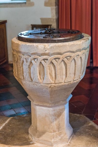
Inside the church is a beautifully carved 12th-century font decorated with blind arcading. Look for a pair of 17th-century memorials to members of the Bolter family.
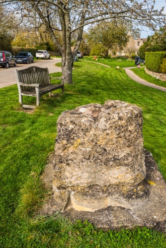
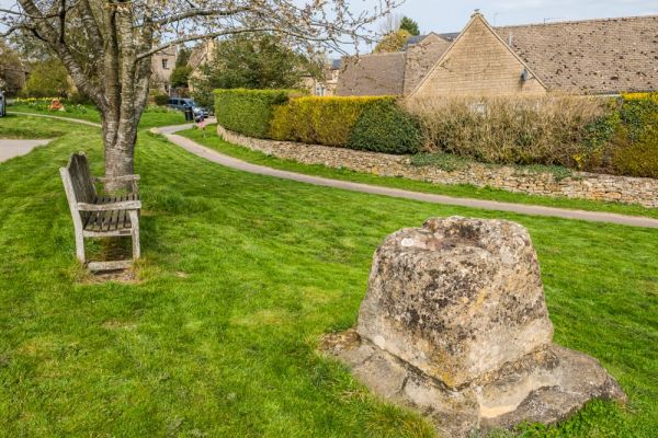
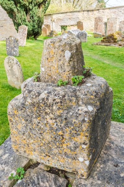
The Ancient Cross
In the long, narrow green along the west side of Chapel Lane is a monolithic block of carved limestone, thought to have been the base of a preaching cross. The cross originally stood beside the A44.
But how old is it?
A small plaque affixed to the cross base makes the rather startling claim that the cross base dates to the very early 8th century. The plaque reads:
This stone originally surmounted by a cross lost long ago, was moved here in 2003 A.D. from the side of the main road. It is thought to have probably been used as a preaching post by travelling friars, dating from about 700 A.D.
English Heritage, who have listed the cross as a Grade II listed building, is much more conservative in their estimate; they suggest a 14th or 15th-century date, which does seem more likely. The cross base is square with chamfered edges on each corner and a square socket hole in the centre.

It looks very similar to the cross in St Mary's churchyard a hundred yards away. Both cross bases are large, square pieces of limestone and both have chamfered corners.
The churchyard cross still has the stump of its cross-shaft, but other than that the two cross bases look almost the same. Could the one on Church Lane actually be as old as the 8th century?
There are six listed buildings in Salford. We've already mentioned three of them; the church, the churchyard cross, and the preaching cross. Others include a table tomb to John Fawdry (d. 1836) in the churchyard, the Old Rectory (c. 1800), and Manor Farmhouse, built in 1683. Both of the latter two are now private dwellings.
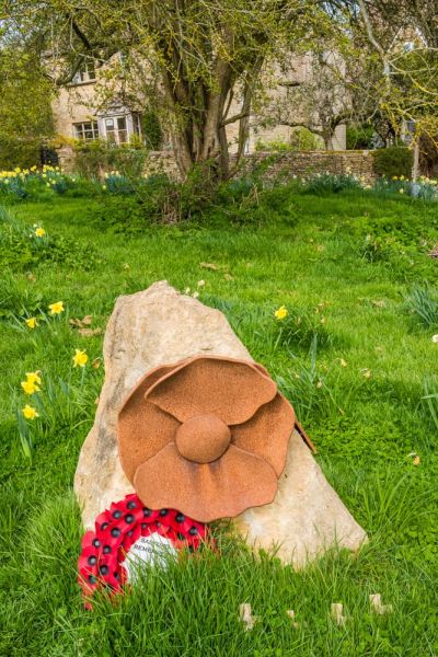
On a small green just off Chapel Lane, between the preaching cross and the church, stands the village war memorial, in the shape of an uncarved piece of local limestone.
The village is served by one inn, the Salford Inn, a traditional country pub located on Lower End, just off the A44.
We came to Salford on a sunny spring day as part of a circular walk along Shakespeare's Way from Chipping Norton. It took us roughly 45 minutes over the fields to reach Salford, a very pleasant 30 minutes exploring the village and the church, and another 45 minutes back, following a bridleway that runs almost parallel to the Shakespeare's Way. It was an extremely pleasant walk, though it might have been muddy in places if the weather had been wet.
More Photos

About Salford
Address: A44, Salford, Oxfordshire, England
Attraction Type: Village
Location: Just off the A44, 1.5 miles north-west of Chipping Norton.
Website: Salford
Location map
OS: SP288279
Photo Credit: David Ross and Britain Express
NEARBY HISTORIC ATTRACTIONS
Heritage Rated from 1- 5 (low to exceptional) on historic interest
Salford, St Mary's Church - 0.2 miles (Historic Church) ![]()
Little Rollright, St Philip - 1.3 miles (Historic Church) ![]()
Chipping Norton, St Mary's Church - 1.5 miles (Historic Church) ![]()
Rollright Stones - 1.9 miles (Prehistoric Site) ![]()
Long Compton, St Peter and St Paul - 2 miles (Historic Church) ![]()
Churchill and Sarsden Heritage Centre - 2.2 miles (Museum) ![]()
Churchill, All Saints Church - 2.5 miles (Historic Church) ![]()
Chastleton House - 2.6 miles (Historic House) ![]()
Nearest Holiday Cottages to Salford:
Chipping Norton, Oxfordshire
Sleeps: 6
Stay from:£727 - £2,530
Chipping Norton, Oxfordshire
Sleeps: 4
Stay from:£674 - £1,923
Chipping Norton, Oxfordshire
Sleeps: 6
Stay from:£847 - £3,160