Alderley Edge
History, tourist information, and nearby accommodation
HERITAGE RATING: 
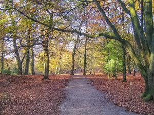
A woodland path at Alderley Edge
A red sandstone escarpment rising above the village of the same name, Alderley Edge provides a lovely walking area with paths winding among mixed woodlands of beech, pine, and oak. There are superb views from the top of the Edge. The unique geology of the area has been recognized by naming the area a Site of Special Scientific Interest (SSSI).
Open all year during daylight hours - see National Trust website for details. Pay and display parking lots (National Trust members free). There is a regular programme of guided walks from April to September. A leaflet outlining walks in the Alderley Edge area is available.
The Edge has been used for copper mining since the Bronze Age. The Romans carried on mining activity, and the Roman mines are open irregularly under the auspices of the Derbyshire Caving Club.
About Alderley Edge
Address: Macclesfield Road, Nether Alderley, Alderley Edge,
Cheshire,
England, SK10 4UB
Attraction Type: Countryside
Location: Parking 1.5 miles east of Alderley village on the B5087 road to Macclesfield.
Website: Alderley Edge
Email: alderleyedge@nationaltrust.org.uk
National Trust
Location map
OS: SJ859778
Photo Credit: Pete Birkinshaw, licensed for reuse under the Creative Commons Licence
HERITAGE
 We've 'tagged' this attraction information to help you find related historic attractions and learn more about major time periods mentioned.
Historic Time Periods:
Roman
Find other attractions tagged with:
Bronze Age (Architecture) -
Roman (Time Period) -

 We've 'tagged' this attraction information to help you find related historic attractions and learn more about major time periods mentioned.