Duncansby Head is the most northeasterly point on the British mainland. The nearby village of John o' Groats has traditionally been publicised as the most northerly point, but that honour goes to Dunnet Head, to the west. Duncansby Head is, however, the furthest point by road from Land's End in Cornwall, the most southwesterly point on the UK Mainland.
As for Duncansby Head, there are two main attractions (aside from the reward of standing on the most northeasterly point of the Scottish mainland). First, there is the lighthouse, built by one of the famed Stevenson family of engineers, and second, there are the dramatic sea stacks known as the Stacks of Duncansby, reached by a walk along the clifftops from the lighthouse car park.
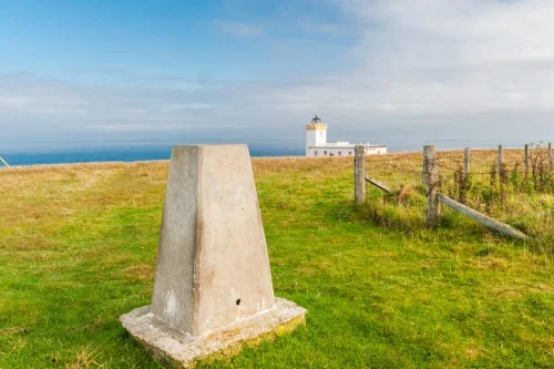
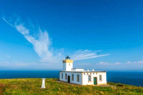
Duncansby Head Lighthouse
Duncansby looks north over the Pentland Firth to the Orkneys. The Firth is a perilous passage for maritime traffic, and its dangers earned it the moniker 'Hell's mouth'. The currents of the North Atlantic Ocean and the North Sea set up dramatic and dangerous tidal races and eddies that can reach a speed of up to 10 knots in places.
To help ships navigate the treacherous waters, Duncansby Head Lighthouse was built in 1924, replacing a WWI foghorn. The engineer behind the lighthouse was David Alan Stevenson, whose family designed and built many of Scotland most famous lighthouses. The Stevensons' most famous member, however, was not an engineer, but a writer; Robert Louis Stevenson.
As for the lighthouse, it is a squat, square structure of concrete, painted white, with a balconied tower that reaches 11m high (roughly 25 feet). Its signal is a white light, flashing every 12 seconds and visible 21 nautical miles out to sea. It stands atop an almost sheer cliff, with a drop of 67m (roughly 148 feet) to the water below.
The lighthouse was bombed by German planes during WWII, but no damage was caused and no one was injured in the attack. A radar beacon (racon) was installed in 1968 but this has since been replaced by a low-power self-operating version.
The lighthouse became fully automated in 1997. There is no public access to the building, but you can easily walk right up to it. It is a bit unusual in that the lighthouse was built in a dip, so that it isn't immediately visible until you get close to it.

Stacks of Duncansby
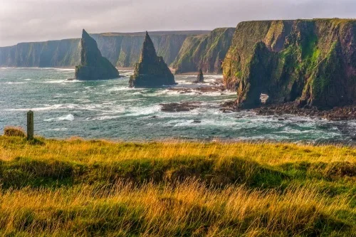
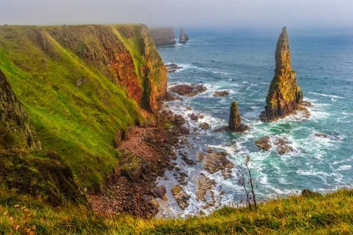
Aside from seeing the lighthouse, the real reason for a trip to Duncansby Head is to visit the sea stacks, located a little less than a mile south of the lighthouse. The going is relatively flat and takes in some of the most stunning clifftop scenery anywhere in Britain.
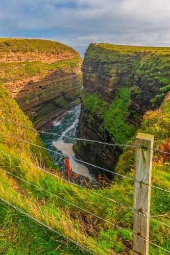
As you head south from the lighthouse along the obvious and well-trodden path, you first come to the Geo of Sclaites, and narrow crevice that splits the rocky cliffs like they had been cleaved with a giant knife. The Geo is home to a colony of seagulls, whose raucous cries fill the air.
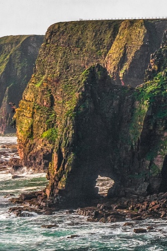
South of the Geo of Sclaites to come to a natural sea arch known as Thirle Door, where the action of the wind and waves has carved a hole through solid rock.
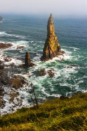
And at last you reach the Stacks of Duncansby, a pair of absurdly jagged, knife-edged pinnacles of rock jutting upwards from the sea. The sea stacks are roughly pyramidal in shape and come to sharp points. You can get great photos of the stacks from almost any angle; just be aware that the sea mist can roll in very, very quickly. You can be bathed in sunlight one minute and shrouded in mist the next. Come at sunset when the sea stacks are light by the golden glow of the sun through the mist. Magic!
Getting There
Getting to Duncansby Head is relatively straightforward. The road is signposted off the A99 in John o' Groats village, opposite the post office. Just follow the lane to the end and you will come to a free parking area in front of the lighthouse.
About Duncansby Head Lighthouse and Sea Stacks
Address: Duncansby Head Road, Duncansby, Caithness, Scotland, KW1 4YS
Attraction Type: Countryside
Location: At the end of a lane from John o' Groats village, opposite the post office. Free parking.
Website: Duncansby Head Lighthouse and Sea Stacks
Location map
OS: ND404733
Photo Credit: David Ross and Britain Express
NEARBY HISTORIC ATTRACTIONS
Heritage Rated from 1- 5 (low to exceptional) on historic interest
Caithness Broch Centre - 6.1 miles (Museum) ![]()
Nybster Broch - 6.7 miles (Prehistoric Site) ![]()
Castle of Mey - 7.2 miles (Castle) ![]()
Keiss Castle - 8 miles (Castle) ![]()
Tomb of the Eagles - 8.1 miles (Prehistoric Site) ![]()
Castle Sinclair Girnigoe - 11.6 miles (Castle) ![]()
Hackness Martello Tower - 11.8 miles (Historic Building) ![]()
Mary Ann's Cottage - 12.1 miles (Museum) ![]()
Nearest Holiday Cottages to Duncansby Head Lighthouse and Sea Stacks:
Nearby accommodation is calculated 'as the crow flies' from Duncansby Head Lighthouse and Sea Stacks. 'Nearest' may involve a long drive up and down glens or, if you are near the coast, may include a ferry ride! Please check the property map to make sure the location is right for you.
John o Groats, Highlands and Islands
Sleeps: 12
Stay from:£1,963 - £5,827
More self catering near Duncansby Head Lighthouse and Sea Stacks