South of Kingarth village, tucked up against a forest plantation, are the partial remains of a stone setting that may once have formed part of a larger stone circle. The standing stones are variously known as the Blackpark Standing Stones (for the Blackpark plantation), or as the Kingarth Standing Stones or Stone Circle.
Three stones remain of the original seven stones, each different in character. Two are conglomerate and the third is schist.
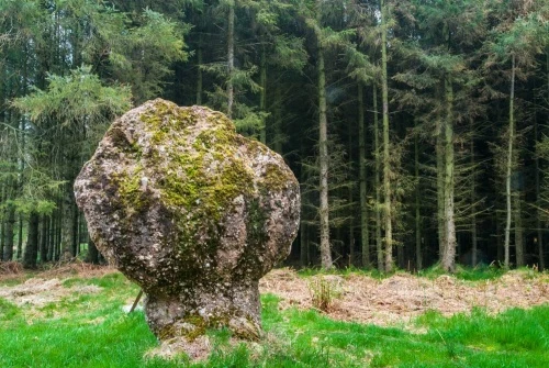
The most striking by far is the northernmost stone, which has a very narrow base and a large, bulbous top, like an oversized mushroom. This stone is made of a peculiar reddish conglomerate. This stone must have fallen at some point in the past and is now supported by a metal prop. It is 2.2m high and 1.1m x 0.5m at the base, broadening to 2.0m x 0.5m near the ovoid top.
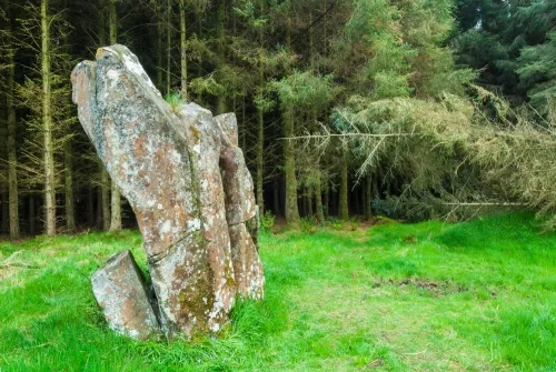
The central stone has large vertical fissures where it has been split by frost. It is very irregular in shape and measures roughly 2.8m high by 2.2m by 1.0m. This stone is of schist.
The southernmost stone stands on a low mound. Like the northernmost stone, it is a conglomerate material. This was damaged in a storm in 1974 and has been restored. It is roughly 2.2m high x 1.3m wide and 0.6m thick. This stone has several examples of graffiti scratched into its surface, and what appears to be an incised cross.
Getting There
From Kingarth village take the A844 west, then turn off onto the unclassified road (Plan Road) to Dunagoil and St Blane's. The road runs along the western edge of the Blackpark Plantation. You see the small airfield to the west of the road, and the stones are almost directly opposite on the eastern side.
The standing stones are immediately beside the road, about 600m from the junction. The location makes the Blackpark standing stones one of the easiest prehistoric monuments in Britain to find. There is a small car park, and from the park you can follow a signposted footpath to the beach at Kilchattan Bay, about 1km to the east.
About Blackpark Standing Stones
Address: Plan Road, Blackpark Plantation, Kingarth, Bute, Argyll and Bute, Scotland
Attraction Type: Prehistoric Site
Location: On Plan Road, between Kingarth and Dunagoil
Website: Blackpark Standing Stones
Location map
OS: NS085559
Photo Credit: David Ross and Britain Express
NEARBY HISTORIC ATTRACTIONS
Heritage Rated from 1- 5 (low to exceptional) on historic interest
Stravanan Bay Stone Row - 0.4 miles (Prehistoric Site) ![]()
St Blane's Church - 1.6 miles (Historic Church) ![]()
Kelspoke Castle - 1.7 miles (Castle) ![]()
Dunagoil Hill Fort - 1.7 miles (Prehistoric Site) ![]()
Scalpsie Bay and Seals - 2.3 miles (Countryside) ![]()
Mount Stuart - 2.6 miles (Historic House) ![]()
Glencallum Bay Lighthouse - 2.7 miles (Historic Building) ![]()
St Ninian's Chapel - 4.6 miles (Historic Church) ![]()
Nearest Holiday Cottages to Blackpark Standing Stones:
Nearby accommodation is calculated 'as the crow flies' from Blackpark Standing Stones. 'Nearest' may involve a long drive up and down glens or, if you are near the coast, may include a ferry ride! Please check the property map to make sure the location is right for you.